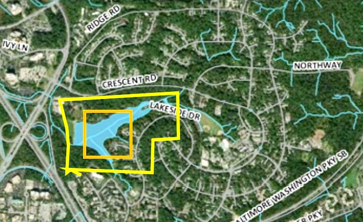
At its September 11 meeting, Greenbelt City Council discussed the U.S. Army Corps of Engineers (USACE) plan for the Department of the Treasury Bureau of Engraving and Printing (BEP) facility and its upcoming final review by the National Capital Planning Commission (NCPC). The planned facility is in the central section of the Beltsville Agricultural Research Center (BARC), between Powder Mill Road to the south and Odell Road to the north. A detailed breakdown of the site plan in a briefing produced by the city’s Department of Planning and Community Development can be found at tinyurl.com/3aae9p7k.
The process is in the final review stage, with a supplemental review scheduled in summer 2024. City staff will testify at a hearing in early October. The full presentation to NCPC is available at tinyurl.com/4mmm5p8m.
BEP’s Updated Design
Director of Planning and Community Development Terri Hruby introduced new staff member Community Planner Ryan Sigworth, who presented the update and commented that it incorporates at least some of the city’s earlier requests, including reducing the reflectivity of the building. He cautioned the audience that the process for the facility was in its final phases, leaving very little opportunity to alter the outcome.
The materials deal only with the site itself and not wider impacts on local traffic; an update on that is anticipated this fall.
Dimensions
The height of the building is in line with mature trees at around 48 feet at its highest point, and the footprint of the building itself is a square, 960 feet per side: ~920,000 square feet, or 22 acres. As shown in the graphic, the building’s footprint is very similar to the surface area of Greenbelt Lake and the area of the overall site to that of Buddy Attick Park, including the lake.
The roof hosts 350,000 square feet (eight acres) of solar array and approximately 550,000 square feet (12.6 acres) of turf or green roof. The building is intended to meet LEED Gold standards.
The exterior of the building is mostly glass in a metallic gray inscribed with BEP’s signature guilloche* patterns similar to those used on banknotes to deter forgers. This patterning is designed to minimize bird strikes.
BEP Traffic Impacts
The entrance for trucks and cars will be on Poultry Road at a new traffic signal on Powder Mill Road. There is an exit onto Odell Road for emergencies and the bulk of the traffic will flow from Interstate 95, either via Route 1 or Kenilworth Avenue/Edmonston Road. All the access roads are currently only one lane in each direction.
Choked Intersections
Councilmember Rodney Roberts noted that these routes to the Beltway are already choked with traffic and the intersections overwhelmed, so the pressure of the additional 1,200+ employees, constant truck traffic, 40,000 visitors annually and 24/7 operations, in his view, almost inevitably will lead to widening Edmonston Road and the loss of wetlands. Roberts also noted the possibility of extending Sunnyside Road (recently widened) east into BARC fields, turning north along an extended Poultry Road.
Vijay Parameshwaran, commenting from the audience, noted that BEP should have already reported any additional impacts but has now delayed doing so until next year. When Parameshwaran asked BEP about vehicle access via Edmonston Road, the categoric reply he received was that Edmonston would be widened. The review documents do show awareness that the intersections between the Beltway and the facility are already inadequate. (Note: when utility poles were recently replaced on the east side of Edmonston Road starting at the recently widened Sunnyside Road and running north to Powder Mill Road, they were relocated about 50’ away from the current roadbed, suggesting that Edmonston Road may be widened.)
Waste Water
USACE has made a change in how wastewater is to be managed compared to its original plan from April this year. In the April plan, the approximately 120,000 gallons per day of wastewater were to be discharged to USDA’s sanitary sewer system and the treated water thence to a tributary of Beaverdam Creek and ultimately the Chesapeake Bay. Contaminants were to be trucked offsite. The plan now proposes that wastewater will go to WSSC Water for disposal via a connection point on Odell Road with pretreatment to remove contaminants to be trucked out as before.
When resident Edith Beauchamp recently inquired about the USACE strategy with WSSC’s Office of Public Affairs, they were apparently unaware of the plan.
Stormwater is to be handled within the site.
At the council meeting, it was incorrectly stated that WSSC does not deal with industrial wastewater, whereas in fact they have a robust and longstanding program for this.
Actions
Council requested staff to prepare a comments document for transmission to USACE and BEP and to follow up on the questions raised at the council meeting, including the wastewater concerns.
*Wikipedia says, “Guilloché (/ɡɪˈloʊʃ/; or guilloche) is a decorative technique in which a very precise, intricate and repetitive pattern is mechanically engraved into an underlying material via engine turning, which uses a machine of the same name, also called a rose engine lathe.
Guilloché is used extensively in designing and printing currency to deter forgers.”

